Gravity: Description of Modules
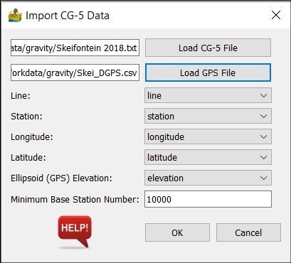
Import CG-5 Data
This module imports CG-5 gravimeter data from either a .txt or a .xyz file (as exported by the gravimeter). The user is also expected to input a comma delimited GPS file with Station, Latitude, Longitude and Elevation columns.
Options:
Load CG-5 file - option to select a .txt or .xyz CG-5 file
Load GPS file - option to load a GPS .csv file.
Line - label for line column.
Station - label for station column.
Longitude - label for longitude column.
Latitude - label for latitude column.
Ellipsoid (GPS) Elevation - label for elevation column.
Minimum Base Station Number - All station numbers larger than this are base stations.
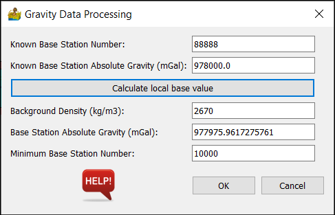
Process Gravity Data
This is a module used to process gravity data, assuming a single base station. It does so according to the North American gravity database standards, as described by Hinze et al (2005)
The input is a line dataset, imported via the gravity menu. Coordinates must be in latitude and longitude, with elevation in meters.
Options:
Known Base Station Number - This is the station number for a base station with known absolute gravity value.
Known Base Station Absolute Gravity - This is the known absolute gravity in mGal for the station above.
Calculate local base value - use this option to tie in the local base station to a nearby base station with known absolute gravity. Note that the local station number must be different from the known station number. There must also be at least one local base station between successive known base station values.
Background Density - This is the background density in kg/m3.
Base Station Absolute Gravity - This is the absolute gravity value of the base station used to correct for drift in the survey. It can be calculated by PyGMI or manually entered.
Minimum Base Station Number - All station numbers greater than this will be considered base stations.