

Import Satellite Data#
PyGMI can import data from the following remote sensing sensors:
ASTER data - Note that this is the data as obtained from https://earthdata.nasa.gov. It can either be in HDF format (there will be an associated MET file) or imported as a ZIP file containing GeoTIFF images. ASTER visible and near infrared (VNIR), shortwave infrared (SWIR) and thermal infrared (TIR) data are provided separately and importing this dataset needs a few extra steps.
Landsat data - Note that this is the data as obtained from https://earthexplorer.usgs.gov. It can either be in L*.TAR.GZ format or extracted, with a _MTL.TXT and GeoTIFF files.
Sentinel 2 data - Note that this is the data as obtained from https://dataspace.copernicus.eu/. It can import the ZIP file, or if extracted the appropriate XML file (e.g. MTD_MSIL2A.xml).
Hyperion L1T data - Data downloaded from https://earthexplorer.usgs.gov. It is imported as a ZIP file containing GeoTIFF images.
WorldView Tile data (TIL) - The tiles will be merged into a single dataset.
ASTER Global Emissivity data - Data downloaded from https://earthdata.nasa.gov in H5 format.
EMIT data - Data downloaded from https://earthdata.nasa.gov. The data are in NC format.
When selecting this function the user has the following options:
Filename -Select the file to be imported.
File Type - The import function automatically detects the type of data and displays it.
All the bands available in the file are listed. The user can select which band/bands to import. By default the bands deemed to contain the data to be used for further processing (e.g. reflectance data) are select. To select/deselect bands simply click on a band name in the list.
Satellite remote sensing data are often provided in UTM coordinates for the northern hemisphere. The user can choose to convert the data from UTM to SUTM.
After the data have been imported, it can be exported to a common raster format by right-clicking on the module and selecting Export Raster Data.
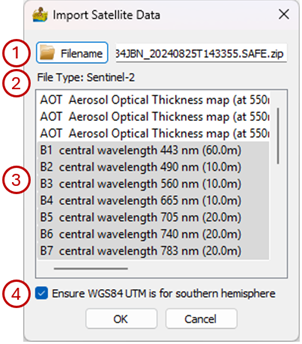
Import Satellite Data interface.#