

Topographic Correction#
PyGMI uses the C correction (McDonald et al., 2000) to effect the topographic correction. The user must import a DEM and, in the case of Sentinel-2 data, the L2A Sentinel-2 dataset resulting from applying the Sen2Cor: Sentinel-2 Atmospheric Correction to L1C data and connect them to the Topographic Correction module.
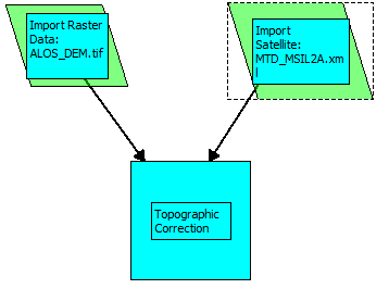
Setting up the Topographic Correction.#
Double-clicking on the Topographic Correction module brings up a dialog box with the following options:
Digital Elevation Model - Ensure that the imported DEM file is selected here.
Solar Azimuth and Solar Zenith - If the L2A Sentinel-2 in its original format is imported using Import Satellite Data, these values will be extracted automatically from the metadata. However, if the Sentinel-2 data have been exported to a standard raster format (e.g. GeoTIFF) and was imported using Import Raster Data, the user will need to enter these values. It is important that the values are as accurate as possible to get the best results.
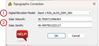
Topographic Correction interface.#
The topographically corrected data can be exported to a standard raster format by right-clicking on the module and selecting Export Raster Data.
References#
McDonald, E.R., Wu, X., Caccetta, P.A., Campbell, N.A., 2000. Illumination correction of Landsat TM data in south east NSW. Paper Presented at: Proceedings of the Tenth Australasian Remote Sensing Conference.