

Import Vector Data#
This module imports ESRI shapefiles (.SHP), zipped shapefiles (.SHP.ZIP), GeoPackages (.GPKG), Keyhole Markup Language (.KML) and zipped KMLs (.KMZ). These formats are also referred to as vector data within PyGMI.
When selecting the Import Vector Data menu entry, the user is prompted for the following information:
Folder locality, filename and format of the input vector file.
Bounds - Vector files can be clipped using the bounds option. This can either be in terms of desired extents entered manually or a mapsheet number.
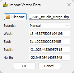
Import Vector Data dialog, options and file formats.#