

Export Raster File List#
Data imported using Create Batch List can be exported to other raster formats, and to a ternary image if desired.
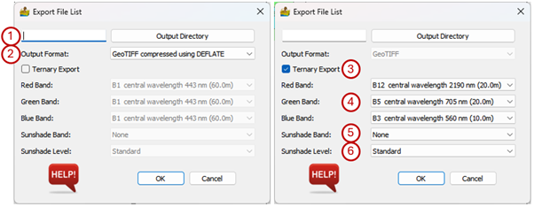
The options are:
Output Directory - The folder where the output files will be stored.
Output Format - File format to export data to. The options are GeoTIFF, GeoTIFF compressed using DEFLATE, GeoTIFF compressed using ZSTD, ENVI, ERMapper, ERDAS Imagine.
Ternary Export - Checkbox to select ternary images to be exported. If this is not selected, the data will be exported to the specified folder with the word _stack appended to the filename. The filename depends on the sensor type and the conventions are as follows:
ASTER - <AST>_<Acquisition date (yyyymmdd)>_<Acquisition time (hhmmss)>
Sentinel-2 - <Sentinel mission (S2A/S2B)>_<Tile name>_<Orbit number>_ <Acquisition date (yyyymmdd)>
Landsat - <Landsat sensors (LT04/LT05/LE07/L08/L09)>_<Processing level>_<WRS path and row>_<Acquisition date (yyyymmdd)>
EMIT - None
If Ternary Export is selected, the exported image files will be exported to the specified folder with the band combination appended to the filename.
Band selection for the ternary image.
Sunshade Band - The band used for the sun shading layer. This can be an external dataset.
Sunshade Level - The severity of sun shading. It can be Standard or Heavy.
Export Raster File List interface.#