

Modelling tools#
This section contains the tools necessary to create the actual model. Modelling in PyGMI works like a paint program, with the user selected a specific lithology and drawing on either the profile or layer view.
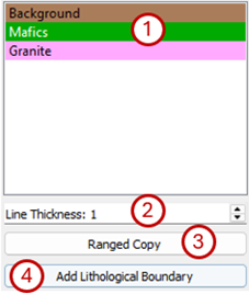
Modelling tools.#
The tools are:
Lithology list - Use this to select the lithology you want to draw in. To erase, simply select the Background lithology and draw with that.
Line Thickness - This allows you to change the pen thickness which you are drawing with. It is in terms of voxel/cell size.
Ranged Copy - The ranged copy function allows for the copying of a lithology on the current profile or layer over a range of profiles or layers. To copy profiles, select Side View and Top View lets you copy layers.
Master Profile - The profile/layer with the lithology/lithologies that you want to copy.
Range Start - The first profile/layer of the range of profiles/layers to which the lithology/lithologies must be copied.
Range End - The last profile/layer of the range of profiles/layers to which the lithology/lithologies must be copied.
Lithologies To Copy - Select the lithologies to copy.
Lithologies to Overwrite - Select the lithologies that can be overwritten.
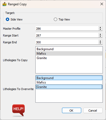
Ranged Copy modelling tool.#
Add Lithological Boundary - Adds a raster to be used as a lithological boundary. It can be used if you have, for example a raster of the surface of the bedrock to add to your model. You will be prompted to select a raster layer and then select how it will be used:
Lithologies Above Layer - You can choose not to change the current model above the boundary layer or select a lithology that must constitute the entire model above the boundary layer.
Lithologies below Layer - Select whether to keep the model unchanged below the boundary layer, or the lithology that must be used for the entire model below the boundary layer.
There are two options for the units of the Z coordinates of the raster layer that will form the lithological boundary. It can either be in depth below the surface or height above sea level.
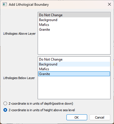
Tool to add a lithological boundary to a model.#
Tip
The ranged copy function for the Layer View can be very useful in getting a starting model going. Draw in your basic lithology boundary based on a geological map or the geophysical data (displayed behind the model) and copy it over a range of applicable depths.