

Profile viewing options#
A toolbar above the Layer View provides options for the profile display, and the ability to import borehole logs.
Options to control the profile display.#
The options are:
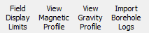
Field Display Limits - This changes the scale of the Y-Axis. This can be important after performing a calculation, to see the full effect of the calculation.
Scale to all maximum - The minimum and maximum extents of the data profile are set to the minimum and maximum of the whole observed and calculated datasets.
Scale to dataset maximum - The minimum and maximum extents of the data profile are set to the minimum and maximum of the whole observed data.
Scale to profile maximum - The minimum and maximum extents of the data profile are set to the minimum and maximum of the observed data along this profile only.
Scale to calculated maximum - The minimum and maximum extents of the data profile are set to the minimum and maximum of the calculated data along this profile only.
Scale to custom maximum - The user specifies the minimum (first value) and maximum (second value) extents for the data profile.
Profile Field Display Limits options.#
View Magnetic Profile - Select the show the magnetic data for the profile.
View Gravity Profile - Select the show the gravity data for the profile.
Import Borehole Logs - Display borehole logs imported using Import Borehole Data. The imported borehole data module must be connected to the modelling module. When Import Borehole Logs is selected in the Profile viewing options the localities of the boreholes will be shown in the Layer View and the borehole lithologies are added to the relevant profiles. The lithologies in the borehole will be added to the lithologies of the model defined in Geophysical Parameters. The user needs to enter the petrophysical parameters for these lithologies.